Formerly Janakpur Engineering College (JEC)Affiliated to Tribhuvan University
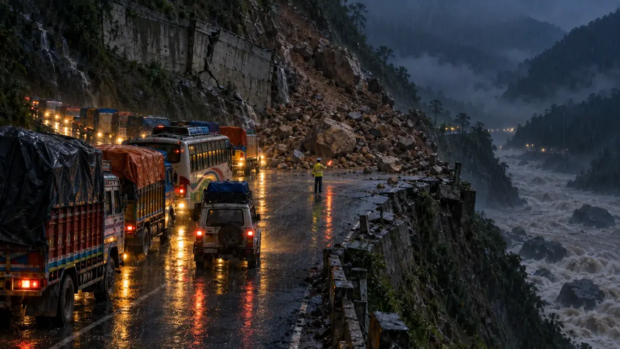
Illustration of trucks stopped at night in heavy rain where a landslide has buried the road above the Trishuli river.
Road statusChecked 27 October 2026

Flood-affected road status

icenepal.com · Imperial College of Engineering · Bhaktapur

Prithvi, Rasuwa and other routes · last checked 27 October 2026

Illustration made with an image model, not a photograph

Roads in this condition change within hours. Before you set out, please ring Traffic Police on 103.

Routes into the Kathmandu Valley, last checked 27 October 2026Routes into the Kathmandu Valley, last checked 27 October 2026Schematic, not to scale. The line style and the label both say the state, not the colour alone.????KathmanduNaubiseMuglinNarayanghatto PokharaHetaudaBidurBetrawatiSyaphrubesiRasuwagadhiTatopaniDhulikhelto SindhuliPrithvi HighwayOpenKanti LokpathNo recent reportMahendra HighwayNo recent reportBP HighwayNo recent reportTribhuvan HighwayOne wayRasuwa roadBlockedAraniko HighwayNo recent reportOpenOne wayBlockedClosed or destroyedNo recent report
Each line shows the newest report we found, and the list under the map names the outlet and date. A road we could not find a recent report on is drawn grey with a question mark, not as open.Imperial College of Engineering. Schematic, not to scale.
  • Prithvi Highway

    Nepal Police reported Galaundi reopened at 6:10 am on 13 October; Nepal Live reported two-way traffic from 6:00 am

    The section subsided on 9 October after Trishuli erosion. The Dhading administration closed it overnight for repairs. Nepal Police reported it open at 6:10 am on 13 October; Nepal Live reported two-way traffic from 6:00 am. Nepal Police’s road notice of 27 October does not list it, which is not the same as a report that it is clear. Check Traffic Police on 103 before leaving; the repaired edge remains vulnerable.

    Sources: Nepal Police road notice, 27 October, to 1:00 pm; Nepal Police road notice, 13 October, 6:35 am; Nepal Live, two-way traffic, 13 October; Kathmandu Post, 12 October; OnlineKhabar, two-way traffic resumed 11 October.

  • Kanti Lokpath (Kathmandu to Hetauda)

    Last reported carrying small vehicles diverted from the Prithvi on 10 October; no newer confirmation found

    Nepalnews reported a landslide blocking the Kanti road at Takurche, Bagmati Rural Municipality-3, Lalitpur, on 2 October. On 10 October, small vehicles were diverted along it while the Prithvi was shut. No later road-status confirmation was found by 27 October, so this page does not label it open. Check Traffic Police on 103 before using it.

    Sources: Kathmandu Post, 10 October; Nepalnews, 10 October; Nepal Police list via DC Nepal, 10 October.

  • Mahendra Highway (Chitwan section)

    No current confirmation found for the Chitwan section after the closure order of 26 September

    The Chitwan administration stopped travel on the Mahendra and Prithvi highways on 26 September (Kathmandu Post). We have not found a report lifting the order. A later police list not naming a road does not confirm it is open. Ask Traffic Police on 103 before you set out.

    Sources: Kathmandu Post, 26 September; Nepal Police list via DC Nepal, 10 October; OnlineKhabar, 10 October.

  • BP Highway (Kavrepalanchok)

    Reported blocked at Pinthali on 10 October and reopened later that day; no newer confirmation found

    The flooded Roshi damaged the Bhakundebesi to Mangaltar section at several places. Nepal Police listed it blocked by mudflow at Pinthali on 10 October; a later report said it reopened, but gave no hour or traffic direction. No newer confirmation was found by 27 October. Ring 103 before using the road.

    Sources: Nepal Police list via DC Nepal, 10 October; newsofnepal via Hamro Patro, 10 October; Kathmandu Post, 1 October; Kathmandu Post, 29 September.

  • Tribhuvan Highway

    One way at Khatri Pauwa, Dhunibesi-9, in Nepal Police’s 13 October notice; not named in the 27 October notice

    Nepal Police’s 13 October road notice says a landslide at Khatri Pauwa, Dhunibesi Municipality-9, has restricted this highway to one-way traffic. The notice gives no schedule. Older reports about time windows farther south are not carried forward because those hours have passed. The 27 October notice does not list this highway, and we found no report that two-way traffic has resumed, so it stays marked one way. Check with Traffic Police on 103 before travelling.

    Sources: Nepal Police road notice, 27 October, to 1:00 pm; Nepal Police road notice via OnlineKhabar, 13 October; Nepal Police flash updates; OnlineKhabar, 25 September.

  • Rasuwa highways (Trishuli to Rasuwagadhi)

    The latest Rasuwa-specific Police report we found, on 13 October, lists the main highways to Dhunche and Rasuwagadhi fully blocked; the Betrawati Acrow bridge was operating in the Nuwakot DAO report of 16 October

    Keep these two facts separate. Nepal Police’s latest Rasuwa-specific notice we found, dated 13 October, lists the main highways through Rasuwa as fully blocked. The Acrow bridge over Phalakhu Khola at Betrawati opened on 11 October, reconnecting Uttargaya in Rasuwa with Bidur in Nuwakot; the district office confirmed the bridge was operating in its 16 October update. This does not reopen the damaged road north to Dhunche, Syabrubesi or Rasuwagadhi. In late September the Department of Roads aimed to reopen Galchhi to Syabrubesi within Asoj and said Syabrubesi to Rasuwagadhi would take a few more months; we found no report by 27 October that either had opened. Confirm the route and vehicle access with Traffic Police on 103 before setting out.

    Sources: Nepal Police road notice, 13 October; Nuwakot District Administration update, 16 October; OnlineKhabar, Betrawati bridge opened 11 October.

  • Araniko Highway and the Tatopani crossing

    Tatopani opened to cargo vehicles only from 18 to 20 October; no regular reopening found

    Infrastructure Development Minister Sunil Lamsal told a parliamentary committee on Tuesday 6 October that the road on the Nepal side had already been reopened, and that the Chinese side did not yet appear ready to resume operations at Tatopani (PTI). On 30 September the Charikot road office had said the Nepali side ran one way during the monsoon. China then opened Tatopani for Kartik 1 to 3 (18 to 20 October) to cargo vehicles only, for Dashain goods, on the Ministry of Industry, Commerce and Supplies’ notice. We found no report of a regular reopening after that, so anything going north through Tatopani should be treated as stopped.

    Sources: DC Nepal, 18 October; Ratopati, Tatopani open for three days; PTI via ThePrint, 7 October; OnlineKhabar, 30 September.

Nepal Police reported Galaundi reopened at 6:10 am on 13 October after overnight repairs, but the notice does not specify lanes or vehicle classes. A separate flood came down the Budhi Gandaki in Gorkhaon 11 October, and that river joins the Trishuli at Benighat beside this highway; what we know about it is on the emergency page.

Last reviewed by Imperial College of Engineering. Each route names the outlet and date it came from.
These routes are outside the Kathmandu schematic above. The latest police update we found is dated 27 October 2026 at 1:00 pm NPT; each line below keeps its own report date. Conditions may have changed; call Traffic Police on 103 before travel.

  • Beni–Jomsom road

    Partially open to one-way traffic at Baisari, Raghuganga-2, Myagdi, in the 15 October report

    The latest report we found for this section says one-way traffic resumed after the landslide. Conditions may have changed; confirm before travel.

    Sources: Nepal Police road update as of 15 October, via OSNepal.

  • Kali Gandaki Corridor

    Large vehicles were restricted at Janti, Baudikali-3, Nawalpur, in the 13 October notice

    No newer confirmation for this corridor was found in the road updates checked on 27 October; the 27 October police notice does not list it.

    Sources: Nepal Police notice, 13 October, via OnlineKhabar.

  • Besisahar–Khangsar road

    One-way traffic was reported in Manang in the 13 October notice

    No newer confirmation for this corridor was found in the road updates checked on 27 October; the 27 October police notice does not list it.

    Sources: Nepal Police notice, 13 October, via OnlineKhabar.

  • Arughat–Dhading roads, Gorkha

    Still fully obstructed in Nepal Police’s 27 October notice

    The 27 October notice says the road is fully blocked because the iron motorable bridge at Soti, joining Arughat wards 2 and 3, was washed away by the Budhi Gandaki flood of 11 October. The 16 October update also listed the bridge from Arughat to Dhading as washed away.

    Sources: Nepal Police road notice, 27 October, to 1:00 pm; Nepal Police road update, 16 October.

Source: Nepal Police road notice, 27 October 2026, as of 1:00 pm NPT.

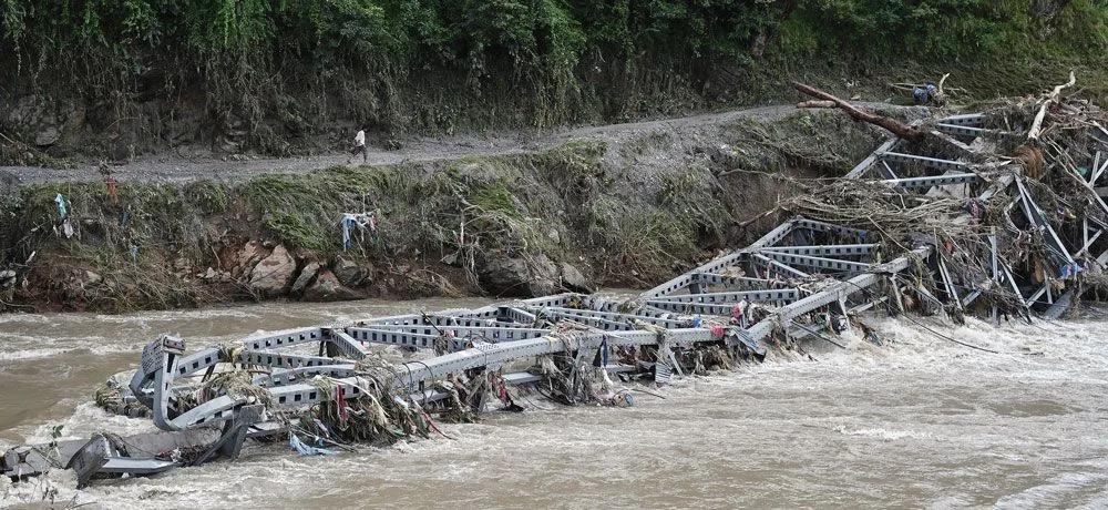
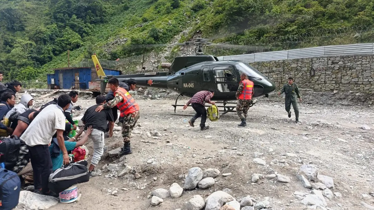
By the count of 30 September 2026, the flood destroyed 33 motorable bridges and 69 kilometres of road between Rasuwagadhi and Malekhu. Where a crossing went, a helicopter was the only way in or out of the settlement behind it. On the Rasuwa road the Army and the Department of Roads were building three replacements:

  • Devighat: a Bailey bridge, finished.
  • Betrawati: a 73-metre Acro bridge, foundations done, five to seven days if the weather allows.
  • Syaphrubesi: a 76-metre Bailey bridge from Army stock, after 100 to 150 metres of slide is cleared.
A steel truss bridge folded into a brown flooded river, with a man walking the road on the far bank
One of the 41 bridges. Where a crossing went, a helicopter is currently the only way in or out of the settlement behind it.Sujan Gurung, The Rising Nepal.
Villagers with bags carried toward a Nepali Army helicopter on a stony riverbank during the flood rescue
A Nepali Army helicopter lifting people out of the flood-hit reach. The Army took 833 people out on 27 August alone, and 13,795 have been rescued since the flood.Nepali Army, via The Rising Nepal.

Sources: Ratopati, 30 September 2026, on the Betrawati track and the two bridges; NDRRMA’s update to 3 October 2026 for the 69 km and the 33 of 37 motorable bridges; Department of Roads figures of 29 August superseded by that count.

A road is only as good as the ground under it, and the ground along this river has changed. The satellite frame below is the same valleys on the day of the flood, and the town beside it sits on a channel a different width from the one it was built next to. Stretches of the valley floor are carrying an estimated ten to eighteen metres of new sediment, which is why rebuilding the road is a survey problem before it is a construction one.

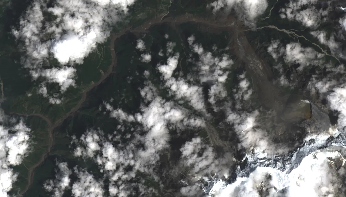
Satellite view of the same valleys on the day of the flood, a wide brown scour running down the river
The same frame on 26 August, hours after. The brown is the river, and it is that wide for 72 kilometres.Landsat 9, USGS.
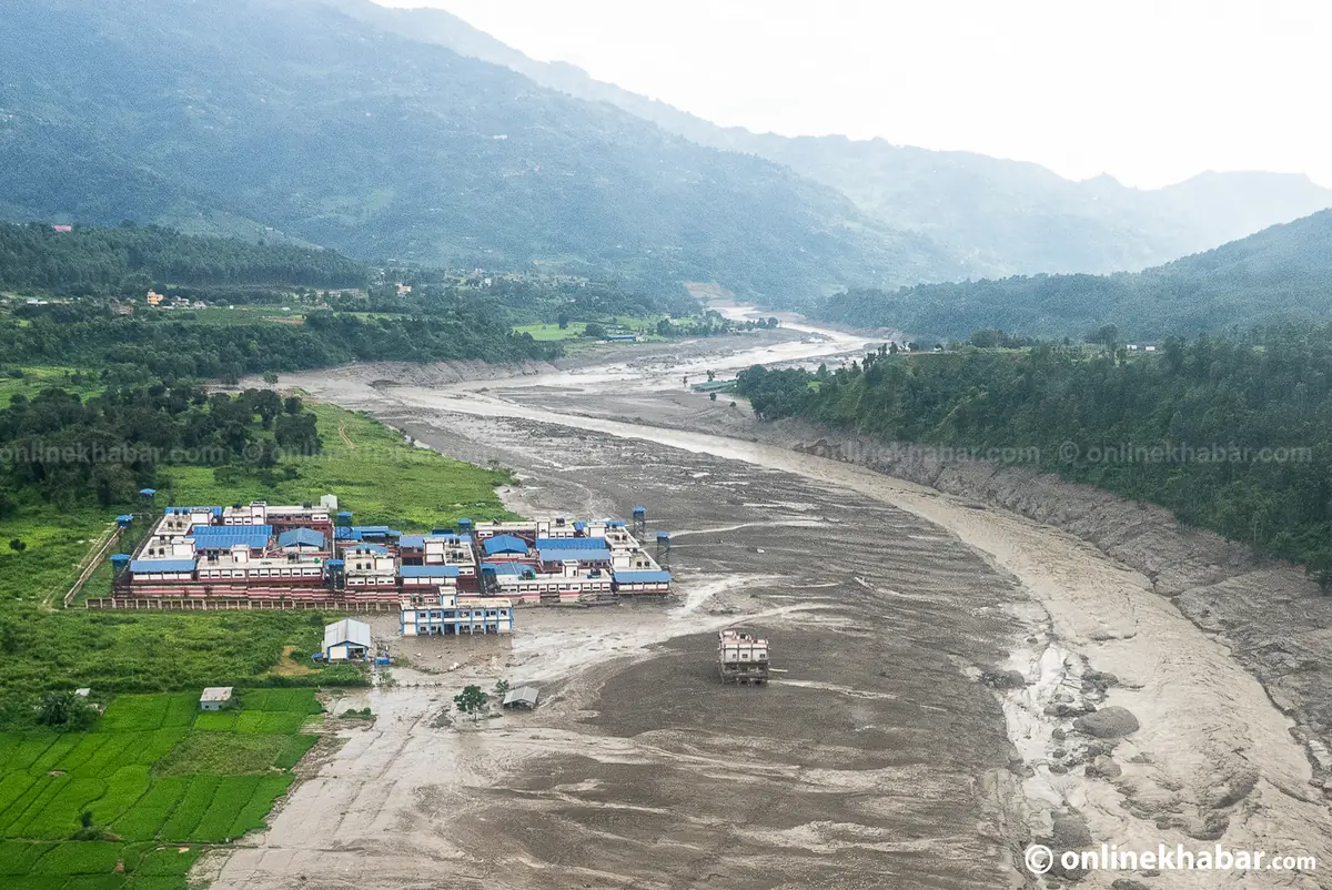
Aerial view of a riverside town with a helicopter overhead beside a river channel widened by the flood
A town on the new edge. Every settlement along this river is now beside a channel a different width from the one it was built next to.Kamal Prasai and Dinesh Gautam, Onlinekhabar.
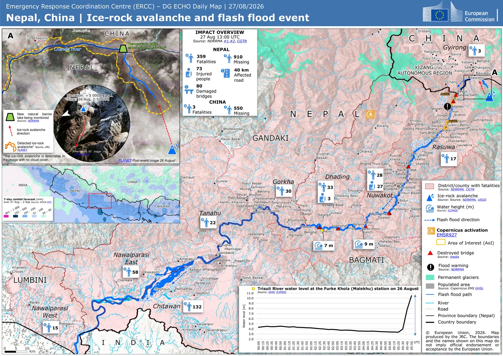
European Commission map of the ice-rock avalanche, the flood path down the Trishuli, and deaths by district
The whole event on one sheet: the avalanche that started it, the path the water took, the districts it killed people in, and the river gauge at Malekhu recording the wave arrive.The impact figures printed on this map are the count at 1:00 pm on 27 August, four days before the ones above it. It is here for the geography, not the numbers.ERCC / DG ECHO daily map, 27 August 2026. European Union.

The slope at Krishnabhir above the Trishuli first failed in 1999 and blocked the highway for more than eleven days in 2000. According to Makalu Khabar, its protective works had a design life of about twenty years, and it started moving again in October 2025. The 26 August flood undercut the road. It reopened on a newly cut track on 17 September, the rain from 24 September brought mud and rock down onto it again, and it reopened to all vehicles on 30 September. The Kathmandu Post reported two-way traffic on 1 October and still listed Krishnabhir among the sections vulnerable to landslides. The next failure was not at Krishnabhir: on the evening of 9 October the road subsided at Galaundi, on the Kathmandu side of Gajuri, where the Department of Roads says the Trishuli had been cutting under it since 26 August, and it was shut until a track was cut into the hillside. On 2 October the Department of Hydrology and Meteorology said no significant rain-bringing system was expected and that the monsoon could withdraw completely by Dashain, though occasional drizzle was still possible. Please still allow extra time at Krishnabhir. The engineering behind that is in our report on the Rasuwa flood and the Krishnabhir landslide.

Sources: Department of Roads via Republica, 26 September 2026; Kathmandu Post, 26, 27, 28 and 29 September 2026; Ratopati, 27 September, 30 September and 1 October 2026; Dhading District Administration Office via OnlineKhabar, 30 September 2026; Nepalnews and OnlineKhabar, 2 October 2026; Kathmandu Post, 1 October 2026; Nepal Police road lists via Ratopati and DC Nepal, 7, 8 and 10 October 2026; Department of Roads DG Bijaya Jaishi via the Kathmandu Post, 10 October 2026; NDRRMA Situation Report #20, 21 September 2026; Makalu Khabar on the history of the Krishnabhir slope. Helplines for every province are on the emergency page.